Monitoring the background seismicity of Tompkins county is essential to revealing if and where seismic activity has been occurring prior to any subsurface activities relating to ESH. Monitoring will continue while the CUBO exploration well is drilled and tested. Data collected before drilling will be compared to data collected during CUBO drilling, to monitor any possible impacts of subsurface drilling activities. Drilling of the exploratory borehole in Summer 2022 will not involve circulating fluids or extraction of heat, as would later ESH activity. Yet understanding of the seismic activity of Tompkins County prior to any new drilling and during simple drilling will be vital information needed during later consideration of the potential risks related to ESH and evaluations of mitigation methods.
Because existing national and regional seismic networks are not sensitive enough to detect seismic activity in Tompkins County, several studies have been undertaken to install new temporary instruments in Tompkins County to detect seismic events — whether earthquakes or human-caused seismic activity.
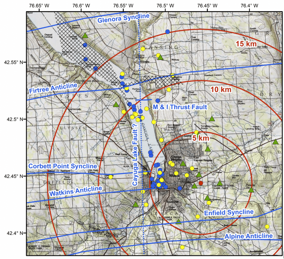
To measure background seismicity, a first network of 12 passive seismometers called CorNET16 (Cornell Network 2016) was deployed from 2015 to 2016. This network provided valuable data about the background seismicity, including 17 events detected in Tompkins County, and is summarized in an online report available here. At the conclusion of the CorNET16 study, it was decided that another background seismicity array covering a larger area and for a longer period of time would be beneficial.
Following the recommendations of CorNET16, CorNET21 was installed in July 2019 and is expected to be in operation until at least 2022. CorNET21 is operated through a contract with an independent company, Weston Geophysical Group. This array of 17 stations includes both surface (buried 2 feet or 0.5 meters) and borehole stations (buried 30 feet or 10 meters). Preliminary analysis of CorNET21 indicated that between August 2019 and January 2021, 359 seismic events were detected in Tompkins County, described in this online report. Among the seismic events detected in Tompkins County by CorNET21, many events were caused by human activities, known as anthropogenic events, including construction vibrations related to Cornell’s North Campus Residential Expansion project and activities around the Cargill Salt Mine.
Further analysis improved the ability to filter out noise in the array (the instruments themselves), human activity at the surface (construction vibrations, for example), and seismic waves from earthquakes that occur outside of the array (earthquakes in Chile or Japan, for example). That filtering allows Weston Geophysical Group to report weekly a clean signal of the very small earthquakes that occur in the county.
An analysis of CorNET16 is reported by McLeod et al. (2020) at https://hdl.handle.net/1813/69609. An examination of the CorNET16 data and analysis of CorNET21 (Suhey et al., 2021) is available at https://hdl.handle.net/1813/103518.
Sources Referenced
McKendree, W., and Y. W. Isachsen, 1977, Preliminary brittle structures map of New York, 1:250,000 and 1:500,000 and generalized map of recorded joint systems in New York, 1:1,000,000: New York State Museum and Science Service Map and Chart Series No.3. http://www.nysm.nysed.gov/researchcollections/geology/gis
Murphy, P. J. 1981. Detachment structures in south-central New York. Northeastern Geology, 3(2), 105-115. National Research Council. 2013. Induced Seismicity Potential in Energy Technologies. Washington, DC: The National Academies Press. https://doi.org/10.17226/13355
Veaner, D., 2017, Mine Shaft Neighbors Meet With Cargill, Lansing Star, https://www.lansingstar.com/around-town/13732-mine-shaft-neighbors-meet-with-cargill
Wedel, A. A., 1932, Geologic structure of the Devonian strata of south – central New York: New York State Museum Bulletin 294, 74 p.