It’s ground-breaking!: Drilling a deep hole for geothermal energy
In summer 2022, the Cornell University Borehole Observatory was drilled to learn about the potential to generate heat in the strata below the Cornell campus. This page tracked progress of the drilling with weekly summaries, which you can still read below (scroll to the bottom to start with the first posts). Cornell researchers have been busy analyzing data and samples since the drilling was completed.
Early results from the Cornell University Borehole Observatory:
Hosts Kiana Duggan-Haas and Roberto Clairmont provide a spring 2023 update of research results from the Cornell University Borehole Observatory. The project team has been focused on determining which sets of pre-existing fractures in bedrock near the base of the borehole might be suitable for harvesting geothermal heat.
Summer ’22 wrap up video:
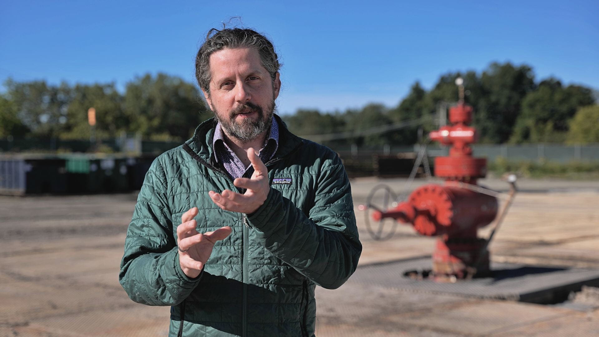
This video, with hosts Kiana Duggan-Haas and Roberto Clairmont, visually summarizes drilling the Cornell University Borehole Observatory in summer 2022 and features project scientist Patrick Fulton briefly summarizing the drilling process and next steps in investigating the potential for deep geothermal heat as a major source of heat.
CUBO Summary of Summer ’22: September 2, 2022 weekly update
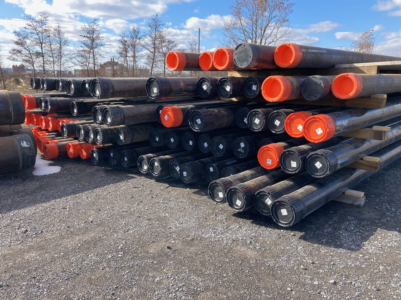
The past week was much quieter at the CUBO well pad, where nearly all of the major drilling-related equipment had been removed, as shown in the well site photo below; workmen continue to remove the temporary buildings and ancillary vehicles and supplies visible along the periphery of the site. In the center of the photo as well as behind Patrick Fulton (Cornell Earth and Atmospheric Sciences) in the photo on the right is a red well head which covers the borehole.
Soon a fiber optic cable will be extended to the bottom of the borehole. That will begin another set of measurements of temperature which use the cable as the sensor. These activities will not require the sort of equipment needed to drill the wellbore.

Over the course of the the summer of 2022….
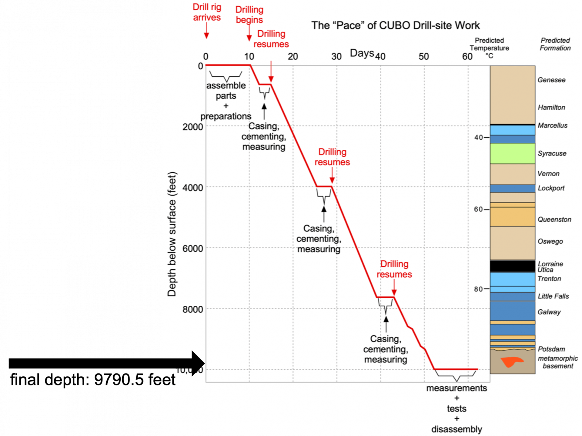
Time it took for drilling: For 54 days, drilling or casing or cementing was in progress, spanning June 21st to August 13th (54 days, or just under 8 weeks).
It took about two weeks for equipment to arrive and be set up before drilling began. Then, immediately after drilling ended, it took about a week to do scientific testing and another week to move offsite most of the rest of the equipment. Thus, from the time of construction of the well pad to moving most equipment away was about 12 weeks.
However, it’s important to recognize that the project had been planned for well over a decade, and much more research and development are intended for years into the future.
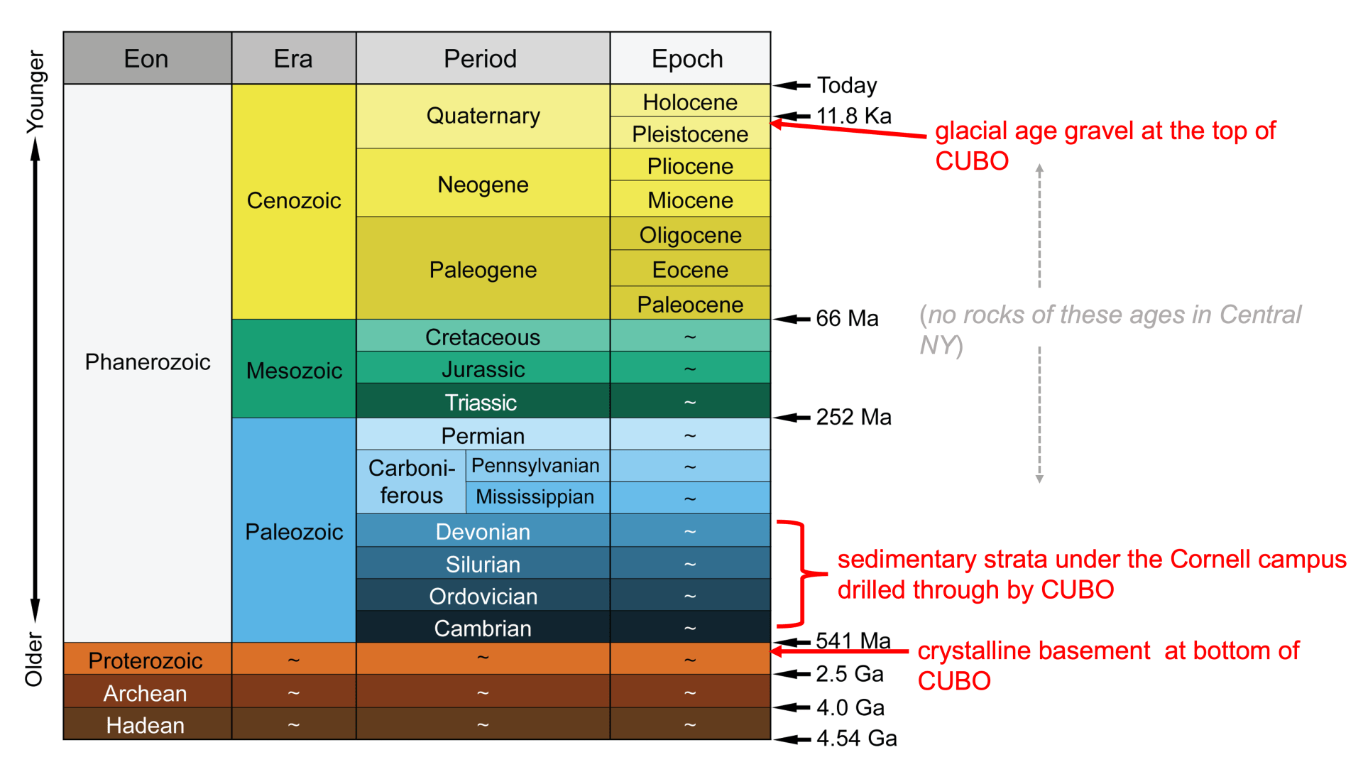
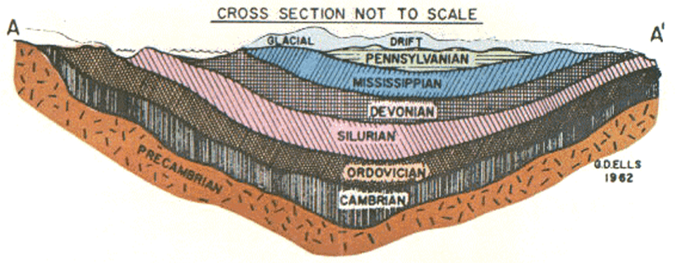
Geologic history observed: The 300 feet of crystalline basement at the bottom of CUBO is over a billion years old, from a time before animals had originated; it may be similar to the rock you can see in the Adirondacks. Directly on top of that rock CUBO cut through nearly 9400 feet and 150 million years of marine sedimentary strata. During this stretch of time, about 520 to 370 million years ago, animals diversified in the ocean, and, toward the end, plants and animals began to diversify in coastal land areas. Rocks during this interval of time can be found at the surface in other parts of New York State. There is no younger rock at the surface in Upstate New York other than sediment left by glaciers, mostly from “only” the past 20,000 years; a little over 100 feet of such sediment was the first layer encountered during drilling of the CUBO borehole.
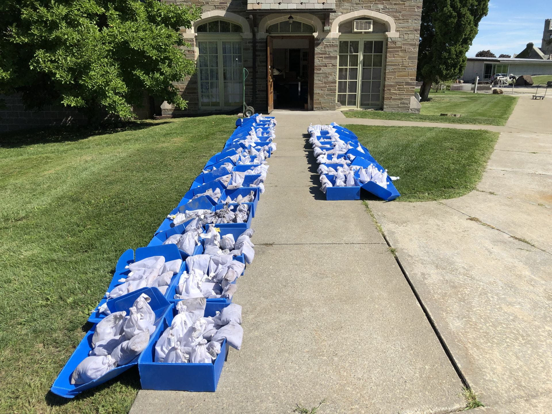
Samples collected: Samples were collected from 1,157 horizons. They were collected for every 10-foot interval from the surface to 7830 feet depth, and then at 5-foot intervals from 7835 feet depth to bottom of hole (9790 feet). The samples were collected in triplicate – 1157 went to the Paleontological Research Institution (PRI), 1157 went to the New York State Museum, and 1157 will remain at Cornell for analyses.
The samples at PRI and the New York State Museum will be stored in research collections for geologists and paleontologists to use for future research. Research collections function like libraries, making samples available into perpetuity to answer future science questions, some of which we may not even be able to imagine today.
Feet of strata drilled: In total, the borehole passed through 9790.5 feet of rock layers (9790 feet = 2980 m = 2.98 km = 1.85 miles).
Those familiar with Ithaca, NY will have seen the landmarks of Cornell’s McGraw (Clock) Tower on East Hill and Ithaca College’s Residential Towers on South Hill; the horizontal distance between, around 10,100 feet, is about the same vertical depth as CUBO. McGraw Tower is 173 feet tall, thus the hole is also about 56 ½ Clock Towers stacked end-to-end!
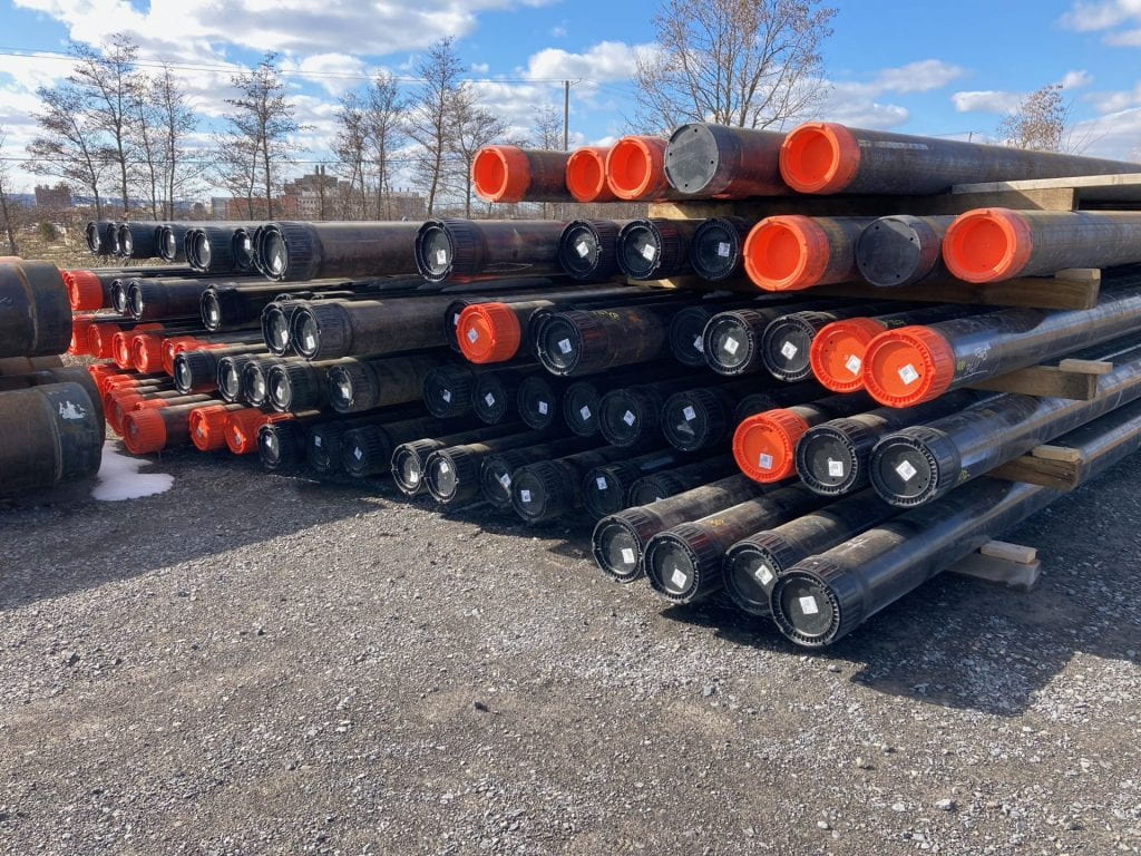
There are about 1.5 miles of steep pipes (casing) in the well, from the surface to 7808 feet depth.
Vertical straightness of weillbore: A slight deviation from vertical occurred with increasing depth. At 6320 ft, the borehole was 1° out of vertical. At 9750 ft depth, the borehole was inclined 4° out of vertical. Consequently, the measured borehole length (9790.5 ft) was slightly longer than the true vertical depth (9788 ft).
Volume of rock drilled and removed: By our calculations, 12,783 cubic feet of rock and sediment were removed from the well. If this rock were shaped into a cube, it would be about 23.4 feet on a side (about the size of a modest-sized house).
Of the total, 778 cubic feet (about 6%) was glacial-age gravel from the top 110 feet of the well (which is the widest part of the well). About 112 cubic feet (slightly less than 1%) was crystalline basement. All the rest (93%) was sedimentary rock from the Cambrian to Devonian periods. Most of that ancient sedimentary rock was made of sand, silt, and clay (and a bit of gravel), which is particles weathered from other rock. Most of the rest of the sedimentary rock was carbonate rocks (limestone and dolostone), made of particles of broken shells, coral skeletons, and other biological materials. A small amount was evaporites, in this case salt and gypsum, which are made of crystals that precipitated in supersaturated warm shallow sea water.
On the Earth Source Heat website this week: See the most recent, and final, Earth Source Heat website video update for an interview with Rick Burgess, Vice President of Facilities and Campus Services and co-chair of the Sustainable Cornell Council. He discusses the recently completed drilling, ongoing research and analysis of the properties of the rocks viewed in the borehole, and potential next steps for a demonstration well pair for geothermal energy.
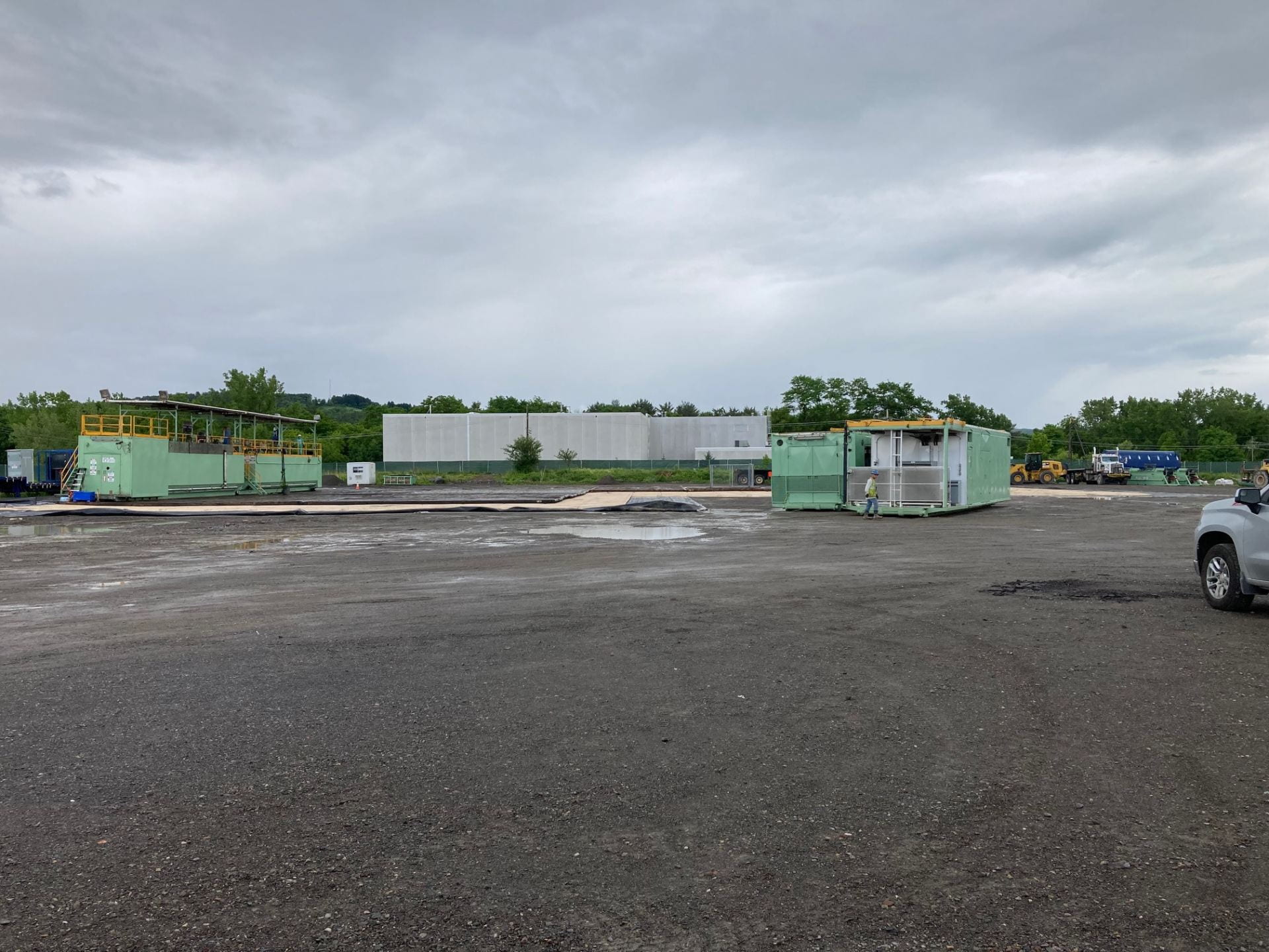
CUBO complete! August 26, 2022 weekly update
In the past week, the final tests were done on the CUBO well and much of the equipment at the site was dismantled and moved. The next phase of the project is to analyze the considerable amount of data that has been collected.
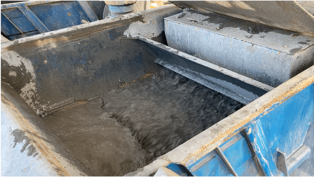
The final experiments were “air-lift production tests,” to measure how much water flow can occur in the fractures within each geological formation of the uncased portion of the borehole (the part between about 8000 feet depth and the well bottom). This test was important for knowing how much heat could be provided from this water and which rock layers would be best to target for future geothermal heat extraction. The test involved flushing the drilling mud out of the borehole, replacing it with water, and using compressed air to push water through permeable parts of the rock.
The weekly seismic monitoring report from August 28th is posted on the Cornell seismic network page, together with reports from past weeks. No events greater than magnitude 1 have been detected, consistent with background activity.
")
")
On August 22nd, after all the scientific tests had been completed, deconstruction of the drill rig began, and the derrick was lowered and dismantled.
The numerous components of the drill rig assembly were lifted and set onto trucks to be moved offsite (see images to the right and below, courtsey of PSP).
The borehole itself will remain, with a modest amount of smaller equipment for long-term monitoring and future tests.

_PSP")

On the Earth Source Heat website this week: See the most recent Earth Source Heat website video update for an interview with EAS geochemist Nicole Fernandez, who talks about monitoring the water chemistry of Cascadilla Creek and also about deep water samples from CUBO.
August 19, 2022 weekly update
This past week, another 178 feet of basement rock were drilled, and on August 13th, the CUBO borehole reached its final depth — 9790.5 feet. The rocks at this depth are various kinds of metamorphic rocks, primarily gneiss with smaller amounts of schist. It is the rocks in the bottom 2000 feet of the well, from the Cambrian sedimentary Galway and Potsdam to the metamorphic basement rock below it, that are the target for geothermal heat. Since the well was finished, a variety of measurements have been collected and tiny horizontal cores taken along the sides of the well. Ultimately, researchers want to know whether and which fractures will have capacity to transmit enough fluids to be able to extract large amounts of heat.

The shape of the borehole wall was drilled to be circular, but it becomes an elongate (oval) shape due to stresses on the rock (see the diagram above). Measuring the shape of the borehole thus helps geologists understand the orientations of these stresses. The two-part diagram at the right shows the shape of the CUBO borehole in two ways: (1) in (mostly) green is a 3D representation of the borehole width over a length of 16 feet, and (2) as black circles or ovals showing the borehole shape at four depths within the green diagram.

One of the types of wireline tools used in CUBO this past week was a device that drilled small cores of rock from the side walls of CUBO. The rock cores, each about 1.5 “ diameter and 2.5 “ long, were delivered to Cornell’s researchers in individual bottles, marked by the depth at which each was collected.
")
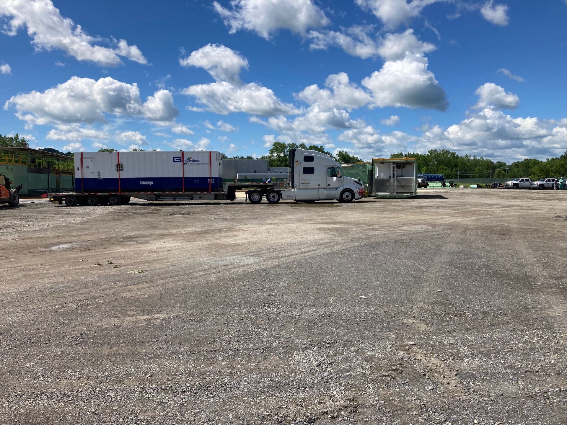
The photograph to the right shows the CUBO site while a “wireline survey” was being conducted. The blue and white logging truck on the right side of the photograph of the drill rig is a laboratory-on-wheels that drops a set of scientific instruments by uncoiling a cable down into the borehole. The back end of the truck faces the well and is where the operators sit while controlling the instrument package inside the borehole.


Left: A view from inside the logging truck, looking out the window at the drill rig standing above the CUBO borehole. The cable that is reeled out into the borehole is visible, like a giant spool of thread, immediately outside the window.
Three times during the past week a log of images of the borehole wall was collected, produced by using electrical resistivity of the rock to detect small variations in properties. The tool has sensors that look in four directions simultaneously, creating a picture of the rocks all around the borehole wall. The device leaves four narrow strips, however, in which no image can be collected. The images reveal the distribution the various sorts of rock, complementing what can be learned about the compositions by studying the rock cuttings. Notice the difference between the horizontal layers of sedimentary rocks compared to the complexly patterned metamorphic rocks.

On the Earth Source Heat website this week: See the most recent Earth Source Heat website video update for an interview with project scientist Patrick Fulton, who talks about the upcoming hydrologic tests and also about samples collected to study life living deep in the Earth’s crust..
August 12, 2022 weekly update
In the past week, over 1700 feet of strata were drilled, through 40 million years of sedimentary layers and into metamorphic rock of the “basement.” The basement is the igneous and metamorphic rock that makes up most of the Earth’s crust. It is in this section of sedimentary and basement rocks that deep geothermal heat, close to the temperature of boiling water, may eventually be harvested for heating the Cornell campus. Data collected from experiments in the borehole in the coming weeks will help determine the viability of using this energy source.
The sedimentary strata included part of the Tribes Hill Formation (early Ordovician period, about 480 million years old), and the Little Falls Dolomite, the Galway Formation, and the Potsdam Sandstone, all deposited during the Late Cambrian period (back to about 520 million years ago).
The Potsdam through Tribes Hill Formations can be found at the surface particularly around the edge of the Adirondacks, but the outcrops are not extensive. The Galway Formation in particular is not extensively exposed considering that the thickness of the sequence of Galway layers under the Cornell campus is at least about 700 feet.
The basement rock is much older than the sedimentary layers and was most recently metamorphosed about a billion years ago. Thus, there is a long interval of about half a billion years between the oldest sedimentary rocks under the campus (the Potsdam Sandstone) and the basement rock. Such intervals of “missing time” between layers are called unconformities. This particular interval of missing time is found in many other areas and has been termed the “Great Unconformity.”
In most places the basement rock is covered by sedimentary strata, but one nearby exception is the Adirondack Mountains. The Adirondacks have been uplifted from below, causing the overlying sedimentary layers to weather away, exposing the ancient metamorphic and igneous rocks of the basement rock. The rock drilled at the bottom of the CUBO well are similar to some of those we can see at the surface in the Adirondacks.
Scales of millions and billions of years are difficult to comprehend. Another place where such ages have appeared in the news is in images from the James Webb Space Telescope and its predecessor, the Hubble Space Telescope. To the right is an example of an image of galaxies a billion light years away, that is, their light has been traveling to Earth for a 1 billion years. One of the first images released to the public from the Webb telescope used infrared light from a galaxy cluster labeled “SMACS 0723” that is 4.6 billion light years away — light traveling since the origin of the Earth!

Throughout the drilling process, the way drillers knew which layers were being drilled was through “mudlogging,” the process of analyzing the small bits of rock and mineral grains brought to the surface in the drilling mud. In this week’s video update, Kiana Duggan-Haas and Roberto Clairmont show mudlogging at the CUBO site.
Identifying rock layers from ground up rock that comes to the surface in drilling mud is very challenging, because some of the distinguishing characteristics of rock layers such as textures and colors are harder to distinguish in small fragments. A special example of this challenge is distinguishing between the Potsdam Sandstone and the underlying metamorphic basement rock; though these rocks would be easy to tell apart in hand sample or outcrop, the Potsdam Sandstone is made of small fragments of weathered basement rock that are similar to the fragments of basement rock ground up by drilling.
On the Earth Source Heat website this week: See the most recent Earth Source Heat website video update for an interview with Bert Bland, an engineer in the Cornell division of facilities and campus services. Bland describes how this last section of drilling will enable measurements related to the viability of using deep geothermal heat.
August 5, 2022 weekly update
The final phase of casing and cementing has been completed, and drilling for the last section of the Cornell University Borehole Observatory has begun. A substantial fraction of the time for drilling the CUBO well has been devoted to casing and cementing, which keeps subsurface pressure from collapsing the borehole and prevents fluids under pressure such as natural gas and water from leaking from rocks into the borehole. Last week’s update video provided an overview of the process.
“Casing” is thick metal pipes screwed into one another and inserted into the drill hole. The pipes are just slightly smaller than the borehole itself. Cement is pumped into the empty space (the “annulus”) between the pipes and the hole. Tests may then be run on the effectiveness of the cementing. The casing and cementing thus ultimately protect the information about geothermal resources that will be collected from the bottom section of the borehole once drilling has been competed.
Much of the remaining drilling through sedimentary layers will pass through layers from the early Ordovician and Cambrian Periods. These layers formed along the coastal edge of what is now eastern North America, analogous to sediments being deposited along the the Atlantic Ocean today. This geological setting contrasts with layers deposited in the shallow inland seas that existed west of mountain ranges from the Late Ordovician to Late Devonian periods.
Some of the Cambrian sedimentary layers are thick and geographically extensive deep below the surface but are not well represented by layers at the surface. Therefore, the cuttings we can see from drilling through these layers allow important observations of subsurface geology that we can’t get any other way.
Geologists are interested in making observations of formations across an area because formations vary geographically, due to variations that existed through time and space in the environments in which the sediments were deposited. Reconstructing geological history requires three-dimension thinking about variations in the thickness and characteristics of geological layers and interpretation of what that means about how environments changed through time and space.
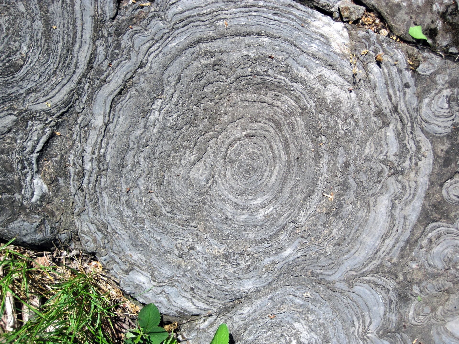
The Cambrian Period is especially notable for its fossil record of the diversification of animal life. The outcrops of Cambrian strata in New York State are relatively limited and are not know for exceptional fossil preservation like some other well-known Cambrian deposits such as the Burgess Shale, but they do hold interesting specimens such as trilobites and stromatolites. Stromatolites are fossil accumulations of bacterial mats and can be found in the misleadingly named “petrified sea gardens” in the Late Cambrian Hoyt Limestone north of Albany, in Saratoga County.
On the Earth Source Heat website this week: See the most recent Earth Source Heat website video update for an interview with Patrick Fulton, on the faculty of Cornell Earth and Atmospheric Sciences, who explains the final phase of drilling and looking for evidence of rock permeability.
July 29, 2022 weekly update
The last phase for the CUBO well drilling is set to begin, which will drill through approximately 2000 feet of rock layers to study the prospects for harvesting deep geothermal heat. These 2000 feet will thus not receive casing, so that the rock walls can be observed with sensitive instruments placed down the well.
Drilling has been paused within the Tribes Hill Formation, from the early Ordovician period, about 490 million years ago. The Tribes Hill Formation can be seen at the surface along the southeast margin of the Adirondack Mountains. The rocks, many layers of which are limestone, were deposited not in an inland sea on the west side of a highland as were deposits from the late Ordovician to late Devonian, but rather from a shallow sea along the eastern edge of what is now North America (then a landmass known as Laurentia).
In the past week, much of the effort at the CUBO site has gone into the process of casing and cementing the section from about 4000 to 7800 feet. The process of casing and cementing is briefly explained in this video featuring graduate student Roberto Clairmont and Professor of Engineering Tony Ingraffea.
See the update from July (below) for more information about video host Roberto.
On the Earth Source Heat website this week: See the most recent Earth Source Heat website video update for an interview with Earth and Atmospheric Sciences PhD student Sean Fulcher, who is studying fractures and minerals indicating fluid flow in the open borehole section that is the target for geothermal heat.
July 22, 2022 weekly update
Over the past week drilling passed through over 2400 feet of strata, including (from upper to lower) the Queenston, Oswego, Lorraine, Utica, Trenton, Black River, and Tribes Hill Formations. These rocks span a significant portion of the Ordovician period, a span from about 450 to 480 million years ago.
To see these formations at the surface in New York State, it would be necessary to visit the southern or eastern edge of Lake Ontario, along edge of the Adirondacks, or along Valley and Ridge in the southeast part of the State. The locations of the layers at the surface represent both the shape of the inland sea where they were deposited and the tilting of the layers and surface topography that control which layers show up at the surface.
The upper formations (Utica up to Queenston) are sediment weathered from mountain building activity that took place in the Late Ordovician period. The Utica Formation, like the Marcellus Group above it in the Devonian period, is a black shale known for its natural gas. Casing has been installed to prevent gases from entering the CUBO well.
The lower formations are largely limestones that were deposited during an interval of relatively clear, reefy environments of the Early to Middle Ordovician, before mountain building that resulted in extensive sedimentary deposits in the Late Ordovician period.
What is the temperature in the borehole?
Because CUBO is a borehole designed to explore for geothermal energy, you might be asking “how hot are the rocks reached this week by the drill bit?” Unfortunately, the CUBO team cannot know the answer to this question until drilling the borehole is finished, and many of the measurements in the borehole are completed. Here’s why.
First, drilling the rock with a steel bit causes friction between steel and rock, friction creates heat, and so the rock temperature at the bottom of the borehole rises above its natural temperature. Second, the fluid used in the borehole – the “mud” which is used to prevent the flow of gas or liquid out of the rock walls, to support the rock walls, to lubricate the bit, and to float the ground-up rock cuttings back to the surface – itself disturbs the temperature of the rock walls.
The mud is heated and cooled by a long list of actions. First, although the mud is initially made by mixing with the water routinely used at Cornell for all campus purposes, that water is stored in tanks that grow hotter in the warm summer air, and consequently that sun-warmed water is progressively added as more mud volume is needed. Second, the mud is heated by friction as it flows past the drill pipe and the rock walls: the higher the rate of flow of the mud, the higher the temperature rises in the mud. Now that CUBO has several lengths of casing inside the borehole, the heating caused by friction is complicated to estimate — the mud flows slower in the near-surface casings because their diameter is wide and therefore the mud heats up only a little, while simultaneously the mud flows faster in the narrower part of the borehole that hasn’t been cased yet and there it heats up more.
To make the temperature of the mud even more complicated, the rocks at all depths of the borehole are either conducting heat to the mud – in the lower part – or receiving heat from the mud – in the upper part. The deeper the drilling continues, the more length of the borehole is through hot rock, and the smaller percentage is through cool rock. There are enough heat exchange factors involved that the question of the mud temperature would make an interesting assignment for a college engineering problem set!
What we have observed in CUBO affirms this complexity. At 4000 feet depth, drilling stopped for the time span needed to confirm the borehole diameter, install steel casing, and cement that casing in place. At this depth the natural rock temperature is predicted to be about 113 °F (45 °C). At the time drilling stopped, the mud that flowed up out of the borehole reached the surface at a temperature of 145 °F, whereas the next day a thermometer placed at the bottom of the borehole recorded 126 °F. A week later when CUBO’s drill bit was at 5800 feet depth, the natural rock temperature is predicted to be about 140 °F (60 °C) and the temperature of mud put into the borehole was 116 °F. There, the temperature when the mud came back out of the borehole was 130 °F. Even though the drill bit was 1800 ft deeper in rocks at the bottom which are likely 27 °F hotter than those at 4000 ft, the mud was cooler!
For the time being, we report the predicted temperatures. The predictions are based on the temperature reported to the New York DEC at the end of drilling in other gas exploration boreholes in south-central New York. Those numbers were probably inexact, but they are the best available data until CUBO can provide its own temperature recordings after the drilling ends, circulating mud in the borehole ends, and testing provides better information.
At the current borehole depth (about 7800 ft), the natural rock temperature is probably close to 172°F (77°C).
On the Earth Source Heat website this week: See the most recent Earth Source Heat website video update for an interview with Earth and Atmospheric Sciences Masters student Daniela Pinilla, who has been helping with the “mudlogging” process of retrieving and studying rock cuttings (small pieces of rock) as they come to the surface during drilling.
July 15th weekly update
In our 4th video update, host Kiana Duggan-Haas gives us a brief overview of the process of drilling CUBO. Drilling occurs 24/7 except when paused to change drill bits, install casing, and similar equipment changes.
This past week drilling progressed about 1200 feet downward, through (from upper to lower) the Vernon, Lockport, Clinton, Oneida, Medina, and Queenston geologic units, with a pause between the Vernon and Lockport formations to insert casing and cement. These units represents a geological timespan of about 30 million years.
The Vernon Formation is part of the Late Silurian period Salina Group. Like the Syracuse Formation above it (drilled through the previous week), the formation is made mostly of shale, but contains layers of salt and gypsum precipitated from sea water. Such precipitated minerals – evaporites – formed when the shallow sea that covered the region became isolated from the rest of the ocean, and warm climates caused evaporation across the broad shallow water body of the inland sea.
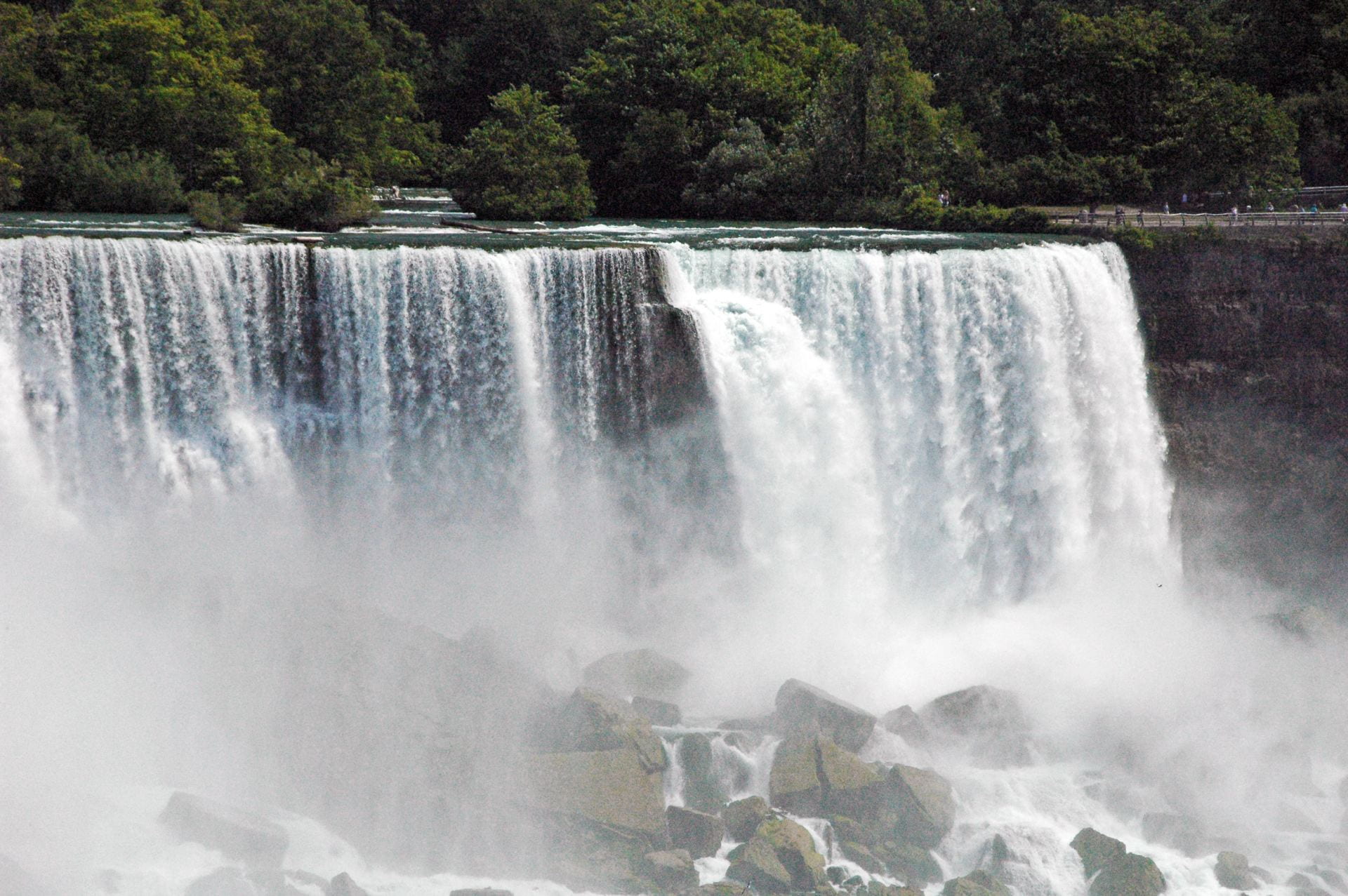
The Lockport Formation is made of resistant limestone and dolostone, deposited in a shallow, clear, tropical sea in the Late Silurian period, about 425 million years ago. Like the Onondaga Limestone above it, the Lockport formation layers create a ridge – the Niagara Escarpment — where the formation crops out at the surface. The most famous example is the rim of Niagara Falls, but the escarpment runs all the way from approximately Rochester, NY, through Canada, to Wisconsin.
The Clinton and Medina Groups are Early Silurian in age and collectively contain a wide range of kinds of sedimentary rocks, including numerous limestones, deposited in a variety of environments in the shallow sea.
The Queenston Formation, from the Late Ordovician period, represents rocks formed from sediments eroded from a set of uplifted mountains to the east. In many respects, these layers are analogous to the Middle and Late Devonian period sedimentary layers we saw near the surface when drilling began and that we see in the walls of gorges near the southern tips of the Finger Lakes. The Queenston Formation was deposited in the Queenston Delta in the Ordovician period, just as the Hamilton Group (for example) was deposited in the Catskill Delta to the west of Acadian Mountains in the Devonian period.

On the Earth Source Heat website this week: See the most recent Earth Source Heat website video update for an interview with Professor Geoff Abers, Chair of the Department of Earth and Atmospheric Sciences and a seismologist working with the Cornell seismic network that’s been monitoring seismic activity before and during the drilling process.
July 8, 2022 weekly update
This past week drilling advanced about 2000 feet downward, much of it through rocks of the Late Silurian period, about 425 million years old. These included the Helderberg, Bertie, Camillus, Syracuse, and Vernon rock units, in order from top to bottom. The layers contain a wide range of sedimentary rocks, among them limestones and dolostones, and thin layers of gypsum and salt.
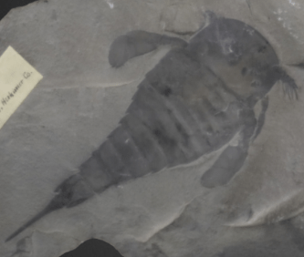
In Bertie Formation rocks, deposited when the shallow sea that covered the region was relatively high salinity, fossil sea scorpions (eurypterids) are found. These sea scorpions are more common and better preserved than those in nearly any other rocks in the world and have been designated the New York State Fossil.
Salt and gypsum precipitated when the shallow sea was cut off from the open ocean and the climate was hot and dry enough for significance evaporation to occur. Salt layers about 8 to 12 feet thick are the basis for salt mining in Upstate New York. The unit that contains them, the Syracuse Formation, comes to the surface near the city of Syracuse, where salt was long extracted from local groundwater. Salt deforms more easily than most other types of rocks, resulting in irregularities in the thickness and shape of the rock layers overlying the salt layers.
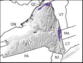
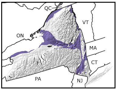
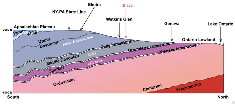
The layers under the Cornell campus can be seen at the surface north of Ithaca; progressively deeper (older) layers are found progressively further north. This is because the sedimentary layers are tilted very slightly downward toward the south, as you can see in the simplified diagram to the right. Topography also plays a role, however, in which layers we see at the surface; lake and stream valleys, for example, expose relatively deeper layers. Note that the sedimentary layers themselves are not uniform; they vary in thickness across space, in part because they extend no further than would have the environments in which they were deposited in the ancient sea that covered the region. They will also have typically experienced areas of at least minor bending (folds) and breaking (faults) after the layers were deposited.
Meet the CUBO Outreach Hosts


We asked our engaging outreach hosts, Kiana Duggan-Haas and Roberto Clairmont (above), of our CUBO videos to tell us a little about themselves. They feature in the videos on the home page and in update videos 1 and 2 below.
Kiana Duggan-Haas (she/her) is an actor and creative originally from western New York currently studying Theatre Arts and Linguistics at SUNY New Paltz. She strives to strengthen the relationship between the arts and the sciences to better engage with both. She believes all art has the capacity to be educational and is proud to be involved in projects like this one where she can use her experience as a performer to contribute to educational resources and science communication.
Roberto Clairmont is from the beautiful twin island republic of Trinidad and Tobago, located in the southernmost region of the Caribbean. He is a 2nd year PhD student at Cornell with undergraduate and master’s degrees in Geophysics, both obtained at the University of Oklahoma. Currently, his goals align with a career path to hydro-geophysics and geothermal exploration as he aims to use his skills and knowledge in advancing sustainable energy practices. Fun fact: Roberto loves Huskies, and for the last few years has grown to like Shih Tzu and Maltese pups.
On the Earth Source Heat website this week: See the most recent Earth Source Heat website video update for an interview with lead project scientist Jeff Tester, Cornell professor of sustainable energy systems in Chemical and Biomolecular Engineering.
July 1, 2022 weekly update
In the past week, drilling has gone from about 800 feet depth to over 2500 feet, extending from rocks from the Late Devonian period similar like those seen in local gorges on campus to rocks from the early Devonian period, rocks from a span of about 20 million years.
Update video 3 features an interview with George Scheid, Capuano Engineering and CUBO Drilling Supervisor, with time-lapse imagery of the raising of the drill rig. Scheid talks about the drilling process and large scale equipment that’s used.
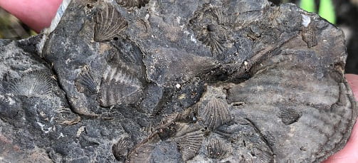
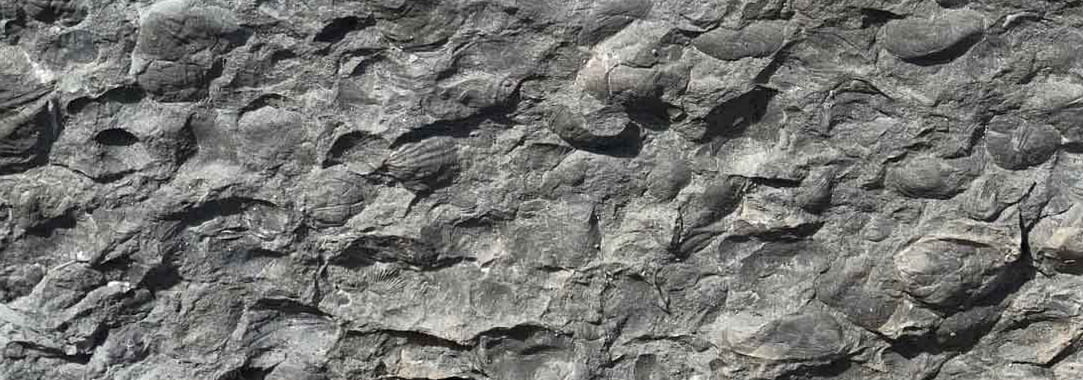
The drill passed through geological layers known as Tully Limestone, a thin, widespread limestone layer, followed below it by the Hamilton Group, which is world-renowned among paleontologists for the quality of its marine fossil record. These rocks can be found at the surface in a band that crosses the Fingers Lakes. The Tully Limestone is mined for gravel and forms the distinctive resistant flat stream bed of Taughannock Creek. The much thicker Hamilton Group is primarily layers of gray shale. Examples of common fossils include brachiopods, bivalves, trilobites, crinoids, horn corals, and much more. Some of the more resistant fossils, such as small horn corals, erode out of the shale and can be found in shallow water along the edges of the Seneca and Cayuga Lake.
The drill also passed briefly through the Marcellus shale (it is less than 100 feet of the 10,000 feet of borehole planned). Steel casing and cement will prevent natural gas from entering the borehole. Ground rock from where the borehole passes through the Marcellus will be analyzed for naturally occurring radioactive materials (NORMs); to learn more, see the pages on NORMs and New York State Geology and NORMs and CUBO.
Below the Marcellus, the borehole passed through the Onondaga Limestone. This limestone formed just before a mountain building a event that resulted in the extensive deposits of sand and mud above it — the Marcellus shale, Hamilton Group, and Genessee Group rocks through which drilling has occurred in the past week. These rocks collectively represent a substantial fraction of the rocks found at the surface south of Route 90 in Central and Western New York.
The Onondaga Limestone formed in clear water where corals and other reef-type organisms thrived. Because the limestone is hard and erosion-resistant, outcrops have formed ridges (escarpments) across the Upstate New York. Below the Onondaga Formation, the borehole passed throgh the Oriskany Sandstone, a very distinctive light-colored coarse-grained sandstone.
See the most recent Earth Source Heat website video update for an interview with Tony Ingraffea, Cornell Professor Emeritus of Civil and Environmental Engineering, about casing and cement sealing of the well.
June 24, 2022 weekly update
On June 21, drilling the Cornell University Borehole Observatory began. The drilling project moves forward toward renewable energy while moving backward through geological history.
The first layers encountered during drilling, down to 225 feet below the surface, were geologically young layers of unconsolidated sediment rich in mud and gravel. The sediment was left behind by Ice Age glaciers that covered the region as recently as 16,000 years ago. The mud and gravel had been dragged along the underside of the glacial ice sheet and was left behind as the ice sheet melted back.
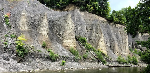
The first bedrock encountered by the drilling was the same as layers we can see in the Cascadilla and Fall Creek Gorges on campus and other local gorges, such as at Treman and Buttermilk Falls State Parks and the upper layers in the cliffs at Taughannock State Park. These layers are mud and sand deposited in a shallow sea that covered Central and Western New York about 380 million years ago (Late Devonian period). You can learn more in Geology of Cascadilla Gorge and Ithaca is Gorges: The Glacial Landscape of the Cayuga Lake Basin and Fall Creek.
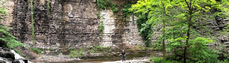
If you look closely on loose rocks in Cascadilla gorge, you may find fossil shells of marine life such as brachiopods. By studying the fossils and sediments layered rocks we can estimate the changes in ancient environments that have taken place over geologic time.
See the most recent Earth Source Heat website video update for an interview with Cornell Professor of Earth and Atmospheric Sciences Terry Jordan.
June 17, 2022 weekly update
A 160-foot tall electric drill rig now stands on the east side of the Cornell campus, on the 3 acre site where the Cornell University Borehole Observatory will be drilled. In the past week, the rest of the equipment necessary to drill the borehole was put into place on the site. Drilling begins the week of June 20th.

Our second CUBO drilling news video features project scientists Patrick Fulton and Roberto Clairmont discussing a concept that is central to deep geothermal energy and CUBO research: how water moves through rocks, which is essential for harvesting heat from the rocks. In a page of the Science Overview section of this website, you can learn more about how porosity, fractures, and permeability affect the transmission of water through rocks.
With the start of drilling, follow “CUBO Activity Tracking” on the home page of the Earth Source Heat website. The tracking includes drilling depth, current rock layer, and the status of water and seismic monitoring. You can see more detailed seismic monitoring reports on this site, on the page about Cornell’s seismic network. On the Earth Source Heat site update this week, you can also watch a video of Cornell graduate Bill Nye talking about the CUBO project onsite.
June 10, 2022 weekly update
This week large trucks have been arriving at the CUBO site. These trucks carry the equipment to construct a 160-foot tall drill rig, together with trailers and associated technology. After a crane lifts the reassembled drill rig into place, drilling of the Cornell University Borehole Observatory will begin. It will take about 2 months to drill the borehole to a depth of about 10,000 feet, the depth at which deep geothermal heat may be sufficient to heat the Cornell campus. A time-lapse camera will capture the action. See a brief interview about recent activities with project scientist Ole Gustafson, Ph.D. ’20, in the June 9th video on Cornell YouTube playlist “Earth Source Heat CUBO: Updates from the Source.”
June 2, 2022 weekly update
Our first CUBO drilling news video introduces the Cornell University Borehole Observatory (CUBO) and the next steps in drilling the borehole. This will include trucks carrying the drill rig arriving on campus the week of June 6th and drilling scheduled to begin the following week.
For video overviews of the project, click on Home in the menu at the top of the page.
May 25, 2022 weekly update
In the first week of June, trucks will arrive carrying equipment to drill a two-mile deep hole on the eastern side of Cornell University’s campus to investigate the idea of heating the campus with renewable geothermal heat. This will be known as the Cornell University Borehole Observatory (“CUBO” for short). CUBO will be an exploration; discovering the rock materials, the fluids, the temperatures, and the stresses beneath the surface. CUBO will be an observatory because the hole will be used for long-term observations of pressure, fluids and heat miles deep If CUBO’s discoveries enable engineers to confirm this deep geothermal heat will be both sufficient and sustainable, a deep geothermal production system may be built in a few years that would help Cornell reach its goal of carbon neutrality by 2035.

Watch this page on the Deep Geothermal Heat website for regular updates on the geology and engineering of the project.
We’ll be reporting on the setup of the electric drill rig and on the two months of drilling through 200 million years of geological strata under Ithaca. We’ll summarize the ancient Earth environments passed as ever deeper layers are encountered. Rock brought to the surface will be studied by project geoscientists and will be saved for museum research collections. Along the way, we’ll also provide updates on geoscience aspects of protecting and monitoring the environment in the area around the borehole. Once the drilling is completed, scientific instruments will be suspended down the borehole to collect information. We’ll report what geoscientists learn and how engineers will use that information to plan for a deep geothermal system to produce heat for the campus.
To learn more about the project, check out the introductory videos on the homepage of this website and dig deeper in the science and engineering overview section. To learn more about how the project fits into the energy plan at Cornell, see the companion site Earth Source Heat.
News – 2022
February 2022 video update:
Wondering what rocks and conditions will be encountered as the geothermal exploration borehole, CUBO, advances downward? In the second video in the series “Going Deep to Solve a Big Problem,” this one titled The Heat Beneath Our Feet, hosts Roberto and Kiana describe the increasing temperatures that are expected, highlight notable rock units that have been exploited as natural resources elsewhere, and briefly describe the rocks targeted as potential geothermal heat reservoirs.
February 2022: Staff of Cornell’s Facilities department are completing numerous steps to finalize contracts with a drilling company, a company that will provide an integrated set of wells services, and to purchase and assemble on site the necessary materials for drilling CUBO. The target drilling date is planned for the latter half of spring 2022.
December 2021 and January 2022: Staff and leadership in Cornell’s Facilities department, in close partnership with faculty, technical staff and leaders of the College of Engineering, are evaluating bids submitted by private companies with the equipment and expertise needed drill the CUBO borehole and perform the services related to drilling, completing, logging and testing.
News – 2021
November 9, 2021: The public visited the intended exploration borehole site. At a set of stations, they spoke to the CUBO project team members and to university staff members who are at the center of efforts to convert campus activities to non-carbon energy sources. Details at: https://events.cornell.edu/event/Cornell_University_Borehole_Observatory_site_visit
September 2021 video update: The first in a series of videos to accompany the Cornell University Borehole Observatory project “Going Deep to Solve a Big Problem,” titled Exploring Geothermal Heat, explains why geothermal heat is an valuable renewable energy source that is needed for the transition away from fossil fuels. Hosts Kiana and Roberto and CUBO project engineers and scientists put CUBO into the context of the energy transition.
September 2021: The first in a series of videos to accompany the Cornell University Borehole Observatory project “Going Deep to Solve a Big Problem,” titled Exploring Geothermal Heat, explains why geothermal heat is an valuable renewable energy source that is needed for the transition away from fossil fuels. Hosts Kiana and Roberto and CUBO project engineers and scientists put CUBO into the context of the energy transition.
August 2021: A new animation of the details of drilling the CUBO borehole has been posted on the main page of the Cornell Earth Source Heat website.
June 2021: Funding has been approved to continue at least through August 2022 the monitoring of natural and anthropogenic seismic signals, and analyzing the data.
May 2021. Nicolás Rangel Jurado successfully defended his Master’s thesis, on the topic “Thermal Performance Evaluations of Fractured and Closed-Loop Geothermal Reservoirs.” Nico’s work was supervised by Assistant Professor Patrick Fulton, with extensive collaboration with Professor Jeff Tester, Post-Doc Adam Hawkins, and NREL’s Koenraad Beckers. After completing the final details of the degree, Nico has begun a doctoral program in the geothermal energy research group at ETH Zurich.
Spring 2021: Capuano Engineering Company has officially joined the CUBO team as Drilling Engineers. Capuano Engineering has worked closely with Cornell’s team to design the drilling and logging technical specifications. They will participate in selection of the most qualified contractors and, when drilling is in progress, one of their engineers will be present on the drill site to provide technical oversight of the contracted drilling, casing, and logging services. Cornell’s team will depend heavily on the advice of Capuano Engineering when reaching decisions about progressive adjustments to plans as drilling proceeds. Capuano Engineering Company has specialized in geothermal wells for nearly 5o years.
19 January 2021: Researchers Professor Teresa Jordan and Engineer Steve Beyers contributed to a Cornell-sponsored virtual Town Hall, to update the community on the research that led to the intended drilling of the Cornell University Borehole Observatory (CUBO), funded by the Department of Energy. Also participating with Rick Burgess, Vice President, Facilities and Campus Services, and Anthony Ingraffea, the Dwight C. Baum Professor of Engineering Emeritus.
News – 2019-2020
01-17 December 2020: As part of the American Geophysical Union Fall Meeting, the AGU TV media activities included a video about Cornell’s aspirations for Earth Source Heat and the soon-to-begin exploratory borehole.
09 December 2020: Graduate student Nicolás Rangel Jurado presented a paper at the American Geophysical Union Fall Meeting, titled “Effects of Realistic Aperture Distributions on the Thermal Performance of Discretely Fractured Geothermal Reservoirs.” His coauthors and collaborators were Assistant Professor Patrick Fulton, Post Doctoral Associate Adam Hawkins, graduate student Ivanakbar Purwamaska, and Professor Jefferson Tester. The paper was in a set of contributions in a session dedicated to “Coupled Flow Processes in Fractured Media Across Scales: Recent Advances in Experimental and Modeling Efforts.”
01 December 2020: A newly published paper in the peer-reviewed journal Scientific Drilling details the opportunities to extend scientific understanding of the hydrology, mechanics and deep biosphere of the continental crust while simultaneously advancing the rigorous analysis of Cornell’s Earth Source Heat aspiration.
September 10, 2020: American Geophysical Unions EOS published a Science Update, “Exploring by Boring: Geothermal Wells as Research Tools” that highlights the ICDP workshop borehole planning activities and the soon-to-be-drilled Cornell exploration borehole.
July 29, 2020: The U.S. Department of Energy’s Geothermal Technologies Office announced that Cornell University was selected to receive funding to drill an exploratory borehole on campus, to test the technical feasibility of extracting deep earth heat to Cornell’s district heating system. The project plan is described by the Cornell Chronicle.
August 27, 2019: The International Continental Scientific Drilling Program (ICDP) sponsored a Workshop to design a science plan for a Cornell deep geothermal pilot well, 8-10 January 2020, in Ithaca, NY.
August 27, 2019: The new semester finds student groups working on the use of tracers to investigate geothermal reservoir performance, and fractures in the basement rocks that are a reservoir target for a Cornell pilot borehole.