As part of monitoring for the Cornell University Earth Source Heat
project, ARA (Weston Geophysical) provides weekly reports on the microseismic
activity in the Ithaca area. Weekly reports start in January 2022
and span the time interval before, during, and after activities relating
to the development of the Cornell University Borehole Observatory (CUBO). The ARA
(Weston Geophysical) contract to perform this work for Cornell University
ends in August 2022.
Seismic events are detected by a network of seventeen seismometers
situated around Ithaca. Fifteen seismic stations were installed by
Cornell University and Weston Geophysical in the summer 2019 (Federal
Digital Seismograph Network code YU), and two stations are part of the
N4 and LD regional networks. Weston Geophysical analyzes these data
to detect and locate seismic events occurring in the Ithaca area. The map
at right shows the approximate extent of the monitoring region. Each weekly
report provides a preliminary overview of the seismic activity
detected within the network coverage area during the past week. Microseismic events in the
Ithaca area are typically associated with a variety of sources: these include
natural background seismicity, noise associated with construction, quarry blasts, mining, and other man-made and natural
sources. Microseismic event parameters presented in the weekly reports are
subject to change following further review.
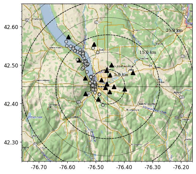 Weekly reported events (red circles; scaled by magnitude), network seismic stations (triangles), background seismicity 2020-2021 (gray circles; not scaled), large circles
represent distance from the CUBO site at center of reticle.
Weekly reported events (red circles; scaled by magnitude), network seismic stations (triangles), background seismicity 2020-2021 (gray circles; not scaled), large circles
represent distance from the CUBO site at center of reticle.
| Report Date: |
2022-08-27 00:00:00 |
|---|
| Data Center: |
Weston Geophysical |
|---|
| Data select start time: |
2022-08-20 03:30:00 |
|---|
| Data select end time: |
2022-08-27 00:00:00 |
|---|
| Number of events: |
0 |
|---|
| Number of network stations: |
17 |
|---|
| Number of stations alive: |
17 |
|---|
| Percent data telemetered: |
85.7% |
|---|
| Orid |
Date/Time |
Latitude |
Longitude |
Magnitude |
Nsta |
Region |
From CUBO |
Quality |
|---|
| |
UTC |
 |
|
 |
# |
|
km |
|
|
|
|
|
|
|
|
|
|

The raw seismic data are openly available through the
Incorporated Institutions for Seismology Data Management Center
(
https://ds.iris.edu/mda/YU/). A description of the techniques used
to analyze the seismic data by Weston Geophysical, as well as
preliminary analysis of events detected from 2019-2021 is available
at
https://ecommons.cornell.edu/handle/1813/69523. Events as small as
moment magnitude (Mw) -2.5 have been detected by the network and analysis is ongoing to
quantify magnitudes for all detected events. The accuracy of microseismic event locations
is estimated to be 500 meters horizontally and
approximately 1 kilometer in depth. Information about the Earth Source
Heat project can be found at
https://earthsourceheat.cornell.edu/about/.
Weston Geophysical is a consulting firm focused on seismic monitoring and geophysical
research. The group is based in Burlington, Massachusetts and is a
division of Applied Research Associates, Inc. Weston’s staff has
expertise in all aspects of monitoring manmade and natural seismicity,
at scales ranging from microseismic to global. Some specific areas of
research focus include advanced signal processing algorithms for highly accurate
seismic event detection, location, and characterization; field deployments
to examine source phenomenology and monitoring induced/triggered seismicity;
seismic coda-based studies of magnitude and other source parameters; regional
surface-wave magnitudes and discriminants; and three-dimensional seismic
velocity models of the crust and upper mantle.