Where in New York state is seismic activity common?
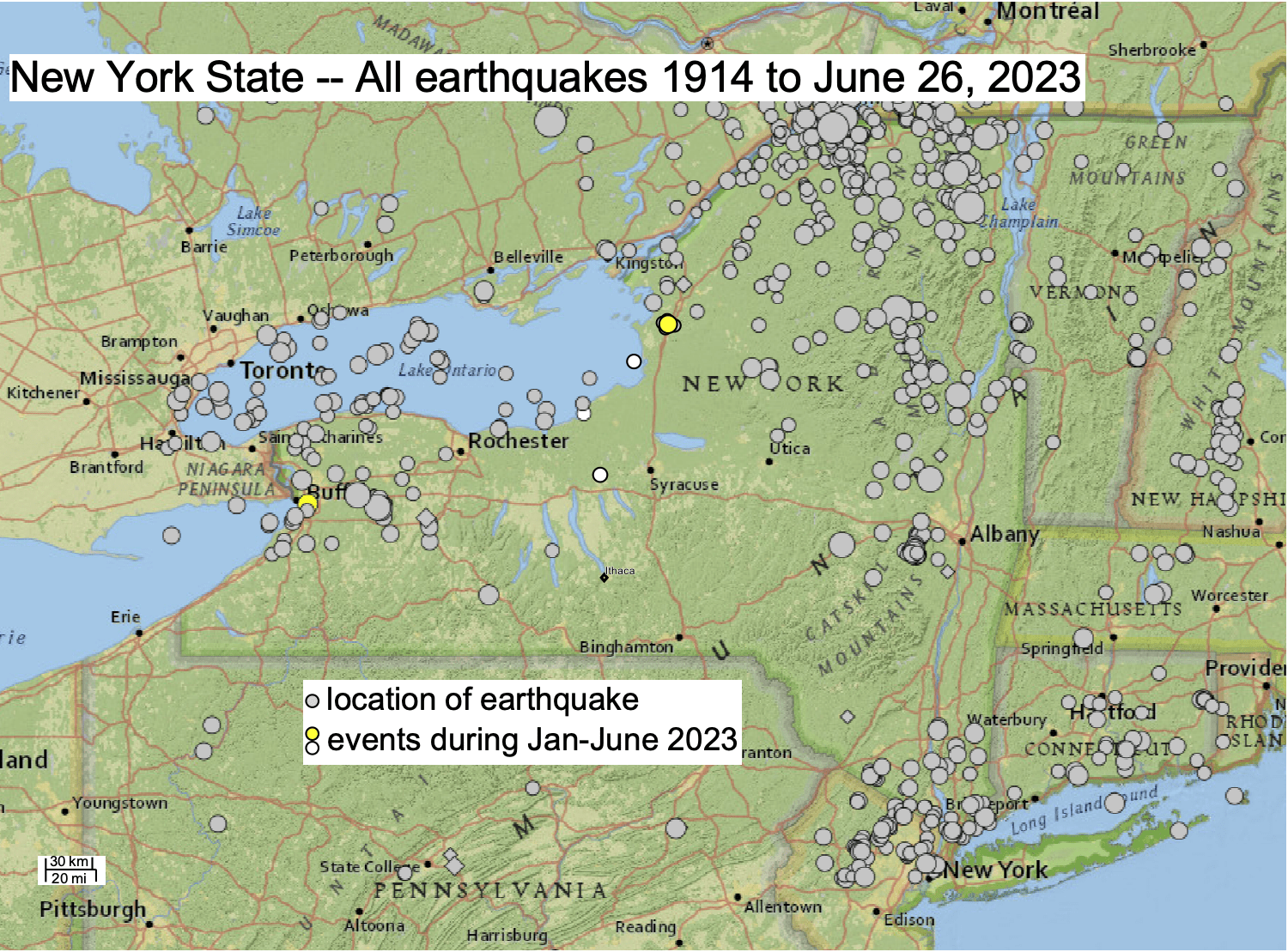
Most earthquakes in New York State occur in three zones, as shown in the map from the U.S. Geological Survey: around New York City, in the Adirondack Mountains, and west of Rochester.
The earliest event within New York that is shown on the map occurred in 1916, near Saratoga. New York’s biggest earthquakes have occurred in the Adirondack Mountains. In 1983, an event with ML of 5.1 occurred near the town of Newcomb, and in 2002 an event with ML of 5.3 occurred in Ausable Forks. For western New York, the biggest events have been a 1929 earthquake about 25 miles east of Buffalo, with ML of 4.7, and events in Attica of ML 4.3 and 4.1, in 1966 and 1967, respectively.
The February 6, 2023, event (yellow dot on the map) near West Seneca, was registered by the U.S. Geological Survey with an ML of 3.8. An April 23, 2023 event (yellow dot) with an ML of 3.6 occurred near Watertown.

The U.S. Geological Survey provides a map of the locations (circles) of all seismic events in and near New York State. Because the availability of data for earthquakes improved markedly over the century, the strength of the earthquakes on the map also changed. For the last two decades, some events with magnitudes as low as 0.1 are shown. Prior to 1975, only events with magnitudes >3 are shown.
What experiences have been reported by New Yorkers?
There have been two earthquakes in New York so far in 2023. On February 6, 2023, an event occurred just 8 km (5 mi) east-southeast of the center of Buffalo (yellow circle). The U.S. Geological Survey reports that the event had a magnitude (the ML scale) of 3.8. Within a 20-mile-distance of the epicenter, over 1500 people reported to the Geological Survey that they had experienced shaking of the sort ranked as IV on the intensity scale, dominantly in communities spanning from Batavia on the east to Fort Erie in southeastern-most Ontario, Canada, on the west. Shaking of intensity II or III was widely reported up to about 70 miles from the epicenter. Among residents who were close to the epicenter, there were numerous reports of a loud noise in addition to vibration, because the source of the earthquake was at a shallow depth below the ground, estimated to be only 3.5 miles. Similarly, a 2020 earthquake in northeastern New York near Glens Falls was somewhat weaker, with a magnitude (the ML scale) of 3.1, yet many some people also heard it – not a surprise, because the seismic waves are sound waves. Vibrations from these events can sometimes be felt hundreds of miles away.
On April 23, 2023, a smaller event, ML 3.6, occurred a few miles southwest of Watertown (yellow circle). Nineteen people within 20 miles distance reported the shaking to the Geological Survey, of intensity IV to III, declining away from the epicenter. This much smaller public response likely is because far fewer people live near the epicenter in Jefferson County (population density about 90 people per square mile) compared to Erie County (population density over 900 per square mile), the site of the near-Buffalo event. Geologically, the two regions are quite similar, and both are common sites of historical earthquakes.
Is the Finger Lakes Region a zone of high or low seismic activity?
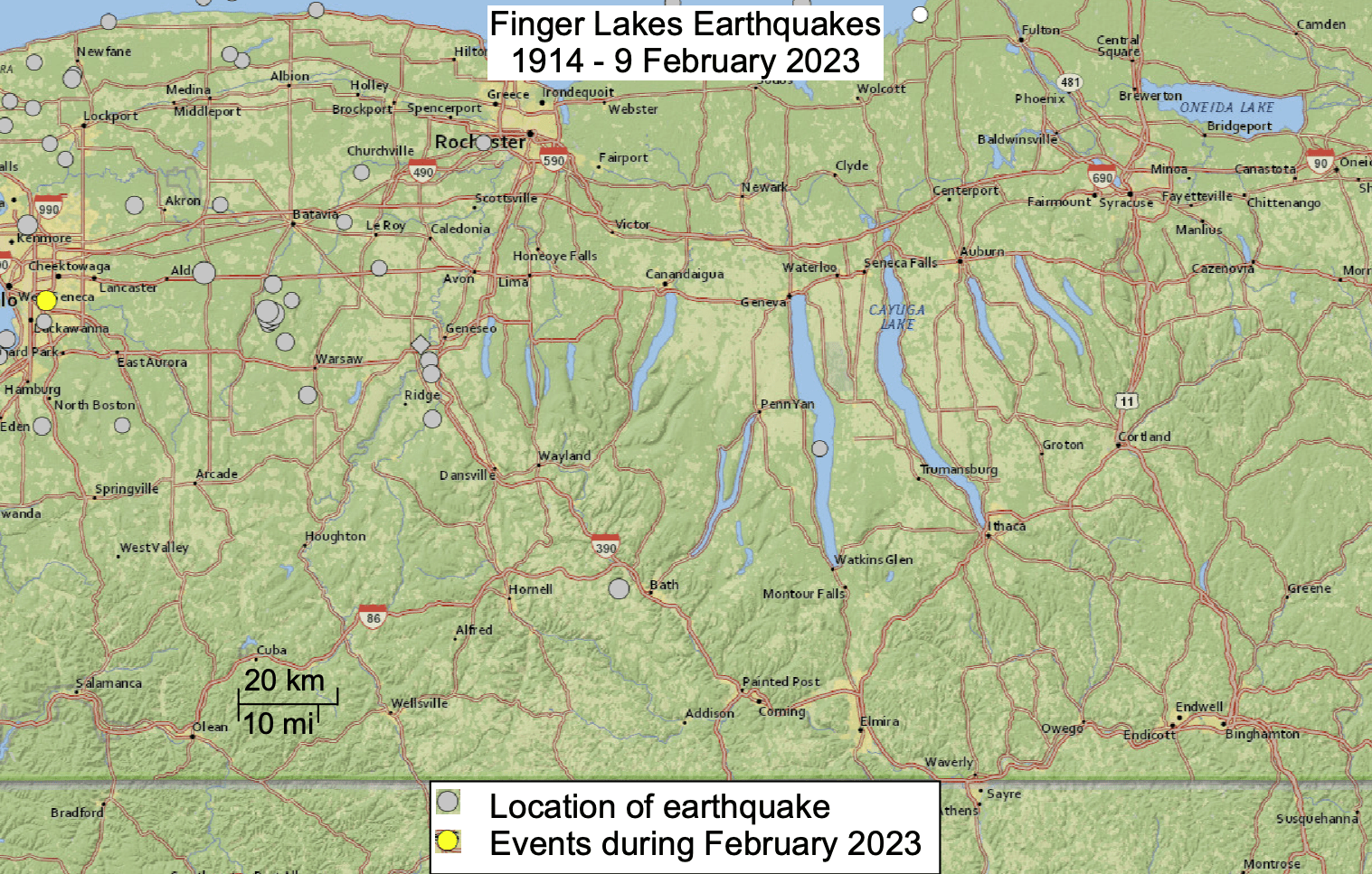
The data show that the Finger Lakes region and New York’s southern tier counties mostly lack earthquake activity. Only two circles on the map mark small earthquakes recorded by the U.S. Geological Survey’s network near the central Finger Lakes district . In 2013 there was one microearthquake under Seneca Lake (ML 1.7). The one shown west of the village of Bath in 2001 was the last in a series of small events within a 10-day-period, the final one ranked on the magnitude scale as ML of 3.2. That series in 2001 stands out as noteworthy both because the earthquakes were comparatively strong in an area with no other events, and because they were activated by human activity – caused by pumping water at high pressure into rocks at 8600 to 10,000 ft depth, to test the capacity of the rocks to accept wastewater disposal. The New York Department of Environmental Conservation required that the injections cease, and the seismic activity ceased.

Do we feel seismic activity in Ithaca?
There is a long record of seismic waves being felt by the inhabitants of Tompkins County. In the historical past, Ithaca would have experienced seismic shaking when there were large earthquakes in the eastern United States and eastern Canada. For instance, studies by the U.S. Geological Survey report that the shaking intensity was likely III or IV in Tompkins County following an 1884 earthquake in New York City, there was shaking of intensity III or IV in Tompkins County due to a 1929 earthquake in Attica New York whose magnitude was 4.4, and earthquakes in the central and northern Adirondacks of magnitudes of 5.1 (1983) and 5.5 (1944) caused shaking of intensities IV and V in the Ithaca region.
Nevertheless, there are many times when our buildings or things in the buildings experience slight degrees of shaking in the Ithaca area and yet the tremors are not caused by earthquakes. Jolts caused by human activity routinely travel through the ground and may be recorded on seismometers, such as mine blasts, construction, heavy trucks or buses lumbering along bumpy streets, and trains. One of the major challenges to determining the history of local earthquakes – their locations, types, and sizes – is to separate these types of human-caused shaking from earthquake-caused shaking.
The Ithaca Journal reported (editions of August 24 and August 26, 2011) examples of what people in Ithaca felt when there was shaking caused by an earthquake. Following a large earthquake in Virginia, on August 23, 2011, a student on the third floor of a building on the Cornell campus was quoted as saying his chair shook, and the Ithaca Board of Public Works sent out staff members to inspect buildings and structures but found no damage. A year earlier, in the June 24, 2010 edition of The Ithaca Journal, there were numerous nearby reports of shaking caused by a magnitude 5 earthquake near Ottawa, Canada: an individual in a building on Clinton Street compared the shaking to what it felt like normally when a bus drives by, yet continuing much longer, and a person standing in a building on Court Street in Ithaca said she felt the floor move.
Digging deeper: More about seismology and earthquakes
Earthquakes: What? Where? How are they measured?
Earthquakes Caused by People
Cornell’s seismic network
